Devils Dome Loop
A 41-mile, 10,000 ft loop through the North Cascades with stunning ridge views, wildlife encounters, snow crossings, and a night camping on top of Devils Dome.

Devils Dome can be hiked clockwise or counterclockwise. Early in the season (mid June to July), lingering snow patches can remain. Doing the loop clockwise means you do most of the snow patches at an upwards angle, counterclockwise you'll do the snow on a downwards slope.
So many trip reports mentioned dense brush, perhaps some work has been done because we didn't find anything that bad. It is certainly brushy in sections and there are many down trees but nothing crazy.
The loop is about 41 miles and 10,000 ft of gain. Most people do the loop in 2-4 days. No permits are needed except for if you camp along Ross Lake. Below is a map with the camps that don't need permits (as well as some photos of them), water sources, snow areas and blowdown areas (all info as of June 20/21 2026).
Day 1
We started the hike at the East Bank Trailhead (48.70795, -120.97798) at 7:30am, we decided to do the hike in two days. We wanted to camp on Devils Dome so it would have been almost 9K ft of gain if we went counterclockwise vs about 7K ft gain our first day if we went clockwise. We picked clockwise, breaking up the elevation a bit more over the two days sounded nice.
It was a fairly nice trail along Ross Lake and we made good time. This section is 12 miles of mostly flat, mostly in the woods with an occasional lake view. You could also take the water taxi/ferry and skip this part. But it costs $190 per group and it only took us 4 hours to hike it.
After you leave the lake then the fun begins! Up, up, up it goes! There were quite a few blowdowns and then the trail got rather brushy. After 5 miles the views finally start! You finally get to see Jack Mountain and all the pain and suffering was worth it.
Another mile and a half and we made it to Devils Dome at 5pm. One other group was there but luckily we snagged the second tent site. Most campsites along this trail are not big and mostly fit one or two tents. We were treated to amazing views, and no mosquitos unlike most other sections of the hike. There is no water on top of the Dome so make sure to fill up before getting there (last water coming in clockwise is at 48.82671, -120.92355). After the Dome we didn't find water for several more miles (next water was at 48.80280, -120.84426, but it was a very small stream).
While eating dinner we watched 6 more people come through, eat dinner on the dome and then continue on going counterclockwise. We were glad we got that last tent site!
Day 2
With a long day in front of us we decided to get an early start and left camp at 6am. The trail was gorgeous and in great shape here. After passing Cinnamon camp the trail got a little brushy again and there were of course more blowdowns. We even saw a bear, but it was far away.
(Try making your own quick backpacking smoothie!)
A momma grouse also popped out of nowhere and started chasing us, we must have gotten too close to her baby! We also saw a badger in this section, lots of animals out here.
Next was a series of snow crossings. Thankfully the snow was soft and we were able to get through it without much issue. The steepest part was below South Jackita Ridge (48.76586, -120.85571). This was a 35 degree angle with a long runout and some rocks here and there. We did speak to one group who was very glad to have had crampons for this section. We didn't have any traction but thankfully it wasn't an issue. Going up the slope instead of down also probably made it feel more secure.
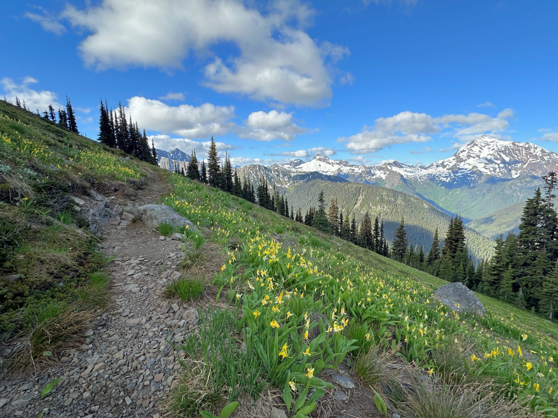
After that we had a few more miles of gorgeous trail before getting to Devils Park. The Yellow Avalanche Lilies were out and lighting up the hillsides. After the shelter most of the views go away and there are many switchbacks to get down to the river.
The trail was in pretty good shape here. Some blowdowns and a little brushy but not bad. Once you get to the river you have three more miles before connecting back to the trailhead. A very large tree fell across the trail here (48.70884, -120.91581), it was definitely the worst and most annoying blowdown we had come across. Lots more brush and more down trees, pretty on par with the first day in terms of brush density. The last mile and a half there were semi fresh woodchips and some trees had been cleared — what a treat! Thank you whoever you are!
We got back to the car at 5:45pm. A great hike with stellar views. We saw 12 groups and 27 people — definitely busier than we thought it would be! About half the hike is in the woods without much of a view, but the mountain scenery was gorgeous!